Provinsi Sulawesi Selatan berhasil menorehkan prestasi membanggakan atas terpilihnya Dinas Tata Ruang dan Permukiman Sulsel dan Dinas Pengelolaan Sumber Daya Air (PSDA) Sulsel sebagai penerima Penghargaan Pekerjaan Umum Tahun 2010.
Kedua dinas ini masing-masing terbaik pada bidang penataan ruang, sub bidang penyelenggaraan penataan ruang yang berkelanjutan, serta bidang pekerjaan umum, sub bidang sumber daya air.
Kepala Dinas Tara Ruang dan Permukiman Sulsel Dr Ir Syarif Burhanuddin M.Eng serta Kepala Dinas PSDA Sulsel Ir Soeprapto Budisantoso MSc dijadwalkan menerima penghargaan tersebut dari Menteri Pekerjaan Umum Ir Djoko Kirmanto pada Malam Penganugerahan Penghargaan Pekerjaan Umum 2010 di Balai Kartini, Jakarta, Jumat (26/11/2010) malam.
Pada bidang penataan ruang, Provinsi Sulawesi Selatan berada di urutan pertama. Bali dan Daerah Istimewa Yogyakarta di posisi kedua dan ketiga. Sedangkan pada bidang pekerjaan umum, Sulawesi Selatan unggul atas Jawa Tengah dan Daerah Istimewa Yogyakarta.
Pemberian penganugerahan ini dibuat istimewa karena akan berisi pertunjukan drama musikal bertema Indonesia Membangun Negeri dan nyanyian dari artis-artis ternama Indonesiaseperti Titi DJ, Vidi Aldiano, Juniar Arif, Warna. Farhan dan Kamidia Radisti akan memandu acara tersebut.
Sumber : Tribun Timur
Jumat, 26 November 2010
Selasa, 23 November 2010
5 strategi nasional pengurangan emisi karbon
Strategi nasional soal pengurangan emisi karbon sudah dituntaskan oleh Indonesia terkait dengan penerapan letter of intent (LoI) moratorium penebangan hutan RI-Norwegia.
Sekjen Reducing Emmisions from Degradation and Forest Deforestation Plus (REDD Plus) Indonesia Heru Prasetyo mengatakan rapat konsultasi telah memfinalisasi lima strategi nasional terkait dengan komitmen Indonesia mengurangi emisi gas rumah kaca dari sektor kehutanan minimum 41% dari komitmen nasional sebesar 26% pada 2020.
Lima strategi itu :
- Menyempurnakan perencanaan dan pemanfaatan ruang secara seimbang dalam upaya menurunkan deforestasi dengan tetap menjaga pertumbuhan ekonomi nasional.
- Meningkatkan pengawasan dan pemantauan.
- Meningkatkan efektivitas manajemen hutan.
- Meningkatkan pelibatan para pihak, terutama masyarakat adat dan masyarakat di sekitar hutan.
- Penguatan sistem penegakan hukum.
"Indonesia akan terus melakukan persiapan. Yang pasti, pengawalan untuk menyelamatkan hutan merupakan komitmen pemerintah," ungkapnya hari ini.
Berdasarkan risalah LoI Indonesia-Norwegia, pada Oktober 2010 dua negara akan melakukan kesepakatan tentang sejumlah program yang telah dirumuskan oleh pemerintah terkait dengan LoI ini.
Pada waktu yang bersamaan, pemerintah Norwegia akan menandatangani kontrak dengan institusi pengelola dana kerjasama bilateral antara Indonesia-Norwegia.
Risalah LoI terdapat tiga tahap kegiatan yang harus dilakukan kedua pihak, masing-masing negara ataupun bersama.
sumber : BISNIS INDONESIA
PRAKIRAAN GEMPA BUMI PERIODE 22 NOV - 5 DES 2010
Sumatera Utara-Nov 25 (+/-3 hari) 3,4 - 5,4 SR.
Radius 500 km dari Medan. Daerah ini, berpusat di Medan pada Lat 3,59° dan Lon 98,67°, membentang dari lepas pantai Banda Aceh turun melalui Simeulue ke Daerah Nias. Sejak tahun 1975, kawasan ini telah mengalami 57x gempa skala 6.0-6.9 SR, 5x skala 7.0-7.9SR, dan 2x gempa bumi besar 8.6 dan 9.0SR
5.2-M7.2
Sumatera Selatan-Nov 25 (+/-3 hari) 5,2-7,2SR.
Radius 500 km dari titik pusat di Pantai Lubuktandjung (Lat -3,60 °, Lon 102,14 °), 350 km sebelah tenggara Padang. Sejak tahun 1975 wilayah ini telah mengalami 68x gempa skala 6.0-6.9SR, 8x skala 7.0-7.9SR), dan 1x gempa besar berkekuatan 8,5 (Desember 2007). Kawasan ini merupakan daerah seismik yang sangat aktif.
Sumber Pustaka : situs gempa bumi
Jumat, 19 November 2010
Menteri Perumahan Minta Pemda Segera Selesaikan Perda Tata Ruang
Menteri Perumahan Rakyat ,Suharso Monoarfa meminta kepada pemerintah daerah agar menyelesaikan perda tata ruang secepatnya. Sebab untuk mendapatkan Dana Alokasi Khusus (DAK) Perumahan yang mulai bergulir tahun 2011 syarat utamanya pihak pemda harus telah memiliki tata ruang.
Menpera menambahkan, pemerintah mengalokasikan Rp 150 miliar untuk kabupaten/kota. Ia berharap Pemda dapat melakukan land consolidation dan land banking, selain itu penataan ruang merupakan hal yang penting dalam penyediaan perumahan bagi masyarakat. Kalau bicara tata ruang pada akhirnya akan menetapkan dalam zonasi tata ruang yaitu permukiman.
Perencanaan pembangunan perkotaan hendaknya memperhatikan konsep Balance Urban Development, dimana diharapkan ada upaya yang maksimal guna menciptakan kesempatan yang sama bagi masyarakat berpenghasilan rendah untuk berkontribusi dalam pembangunan kehidupan permukiman perkotaan yang berkelanjutan terutama dalam memenuhi kebutuhan masyarakat akan hunian layak.
Tata ruang mempunyai peran strategis untuk menuju kesejahteraan masyarakat yang berkelanjutan melalui pemanfaatan sumber daya alam. Pemanfaatan ruang semestinya dapat terencana dengan sebaik-baiknya. Keberhasilan pelaksanaan tata ruang sangat tergantung dari pengendaliannya.
Source : Pos Kota
Sabtu, 13 November 2010

Rabu, 25 Agustus 2010
NASA/NOAA Study Finds El Niños are Growing Stronger

Deviations from normal sea surface temperatures (left) and sea surface heights (right) at the peak of the 2009-2010 central Pacific El Niño, as measured by NOAA polar orbiting satellites and NASA's Jason-1 spacecraft, respectively. The warmest temperatures and highest sea levels were located in the central equatorial Pacific. Image credit: NASA/JPL-NOAA
A relatively new type of El Niño, which has its warmest waters in the central-equatorial Pacific Ocean, rather than in the eastern-equatorial Pacific, is becoming more common and progressively stronger, according to a new study by NASA and NOAA. The research may improve our understanding of the relationship between El Niños and climate change, and has potentially significant implications for long-term weather forecasting.
Lead author Tong Lee of NASA's Jet Propulsion Laboratory, Pasadena, Calif., and Michael McPhaden of NOAA's Pacific Marine Environmental Laboratory, Seattle, measured changes in El Niño intensity since 1982. They analyzed NOAA satellite observations of sea surface temperature, checked against and blended with directly-measured ocean temperature data. The strength of each El Niño was gauged by how much its sea surface temperatures deviated from the average. They found the intensity of El Niños in the central Pacific has nearly doubled, with the most intense event occurring in 2009-10.
The scientists say the stronger El Niños help explain a steady rise in central Pacific sea surface temperatures observed over the past few decades in previous studies-a trend attributed by some to the effects of global warming. While Lee and McPhaden observed a rise in sea surface temperatures during El Niño years, no significant temperature increases were seen in years when ocean conditions were neutral, or when El Niño's cool water counterpart, La Niña, was present.
"Our study concludes the long-term warming trend seen in the central Pacific is primarily due to more intense El Niños, rather than a general rise of background temperatures," said Lee.
"These results suggest climate change may already be affecting El Niño by shifting the center of action from the eastern to the central Pacific," said McPhaden. "El Niño's impact on global weather patterns is different if ocean warming occurs primarily in the central Pacific, instead of the eastern Pacific.
"If the trend we observe continues," McPhaden added, "it could throw a monkey wrench into long-range weather forecasting, which is largely based on our understanding of El Niños from the latter half of the 20th century."
El Niño, Spanish for "the little boy," is the oceanic component of a climate pattern called the El Niño-Southern Oscillation, which appears in the tropical Pacific Ocean on average every three to five years. The most dominant year-to-year fluctuating pattern in Earth's climate system, El Niños have a powerful impact on the ocean and atmosphere, as well as important socioeconomic consequences. They can influence global weather patterns and the occurrence and frequency of hurricanes, droughts and floods; and can even raise or lower global temperatures by as much as 0.2 degrees Celsius (0.4 degrees Fahrenheit).
During a "classic" El Niño episode, the normally strong easterly trade winds in the tropical eastern Pacific weaken. That weakening suppresses the normal upward movement of cold subsurface waters and allows warm surface water from the central Pacific to shift toward the Americas. In these situations, unusually warm surface water occupies much of the tropical Pacific, with the maximum ocean warming remaining in the eastern-equatorial Pacific.
Since the early 1990s, however, scientists have noted a new type of El Niño that has been occurring with greater frequency. Known variously as "central-Pacific El Niño," "warm-pool El Niño," "dateline El Niño" or "El Niño Modoki" (Japanese for "similar but different"), the maximum ocean warming from such El Niños is found in the central-equatorial, rather than eastern, Pacific. Such central Pacific El Niño events were observed in 1991-92, 1994-95, 2002-03, 2004-05 and 2009-10. A recent study found many climate models predict such events will become much more frequent under projected global warming scenarios.
Lee said further research is needed to evaluate the impacts of these increasingly intense El Niños and determine why these changes are occurring. "It is important to know if the increasing intensity and frequency of these central Pacific El Niños are due to natural variations in climate or to climate change caused by human-produced greenhouse gas emissions," he said.
Results of the study were published recently in Geophysical Research Letters.
For more information on El Niño, visit: http://sealevel.jpl.nasa.gov/.
JPL is managed for NASA by the California Institute of Technology in Pasadena.
Lead author Tong Lee of NASA's Jet Propulsion Laboratory, Pasadena, Calif., and Michael McPhaden of NOAA's Pacific Marine Environmental Laboratory, Seattle, measured changes in El Niño intensity since 1982. They analyzed NOAA satellite observations of sea surface temperature, checked against and blended with directly-measured ocean temperature data. The strength of each El Niño was gauged by how much its sea surface temperatures deviated from the average. They found the intensity of El Niños in the central Pacific has nearly doubled, with the most intense event occurring in 2009-10.
The scientists say the stronger El Niños help explain a steady rise in central Pacific sea surface temperatures observed over the past few decades in previous studies-a trend attributed by some to the effects of global warming. While Lee and McPhaden observed a rise in sea surface temperatures during El Niño years, no significant temperature increases were seen in years when ocean conditions were neutral, or when El Niño's cool water counterpart, La Niña, was present.
"Our study concludes the long-term warming trend seen in the central Pacific is primarily due to more intense El Niños, rather than a general rise of background temperatures," said Lee.
"These results suggest climate change may already be affecting El Niño by shifting the center of action from the eastern to the central Pacific," said McPhaden. "El Niño's impact on global weather patterns is different if ocean warming occurs primarily in the central Pacific, instead of the eastern Pacific.
"If the trend we observe continues," McPhaden added, "it could throw a monkey wrench into long-range weather forecasting, which is largely based on our understanding of El Niños from the latter half of the 20th century."
El Niño, Spanish for "the little boy," is the oceanic component of a climate pattern called the El Niño-Southern Oscillation, which appears in the tropical Pacific Ocean on average every three to five years. The most dominant year-to-year fluctuating pattern in Earth's climate system, El Niños have a powerful impact on the ocean and atmosphere, as well as important socioeconomic consequences. They can influence global weather patterns and the occurrence and frequency of hurricanes, droughts and floods; and can even raise or lower global temperatures by as much as 0.2 degrees Celsius (0.4 degrees Fahrenheit).
During a "classic" El Niño episode, the normally strong easterly trade winds in the tropical eastern Pacific weaken. That weakening suppresses the normal upward movement of cold subsurface waters and allows warm surface water from the central Pacific to shift toward the Americas. In these situations, unusually warm surface water occupies much of the tropical Pacific, with the maximum ocean warming remaining in the eastern-equatorial Pacific.
Since the early 1990s, however, scientists have noted a new type of El Niño that has been occurring with greater frequency. Known variously as "central-Pacific El Niño," "warm-pool El Niño," "dateline El Niño" or "El Niño Modoki" (Japanese for "similar but different"), the maximum ocean warming from such El Niños is found in the central-equatorial, rather than eastern, Pacific. Such central Pacific El Niño events were observed in 1991-92, 1994-95, 2002-03, 2004-05 and 2009-10. A recent study found many climate models predict such events will become much more frequent under projected global warming scenarios.
Lee said further research is needed to evaluate the impacts of these increasingly intense El Niños and determine why these changes are occurring. "It is important to know if the increasing intensity and frequency of these central Pacific El Niños are due to natural variations in climate or to climate change caused by human-produced greenhouse gas emissions," he said.
Results of the study were published recently in Geophysical Research Letters.
For more information on El Niño, visit: http://sealevel.jpl.nasa.gov/.
JPL is managed for NASA by the California Institute of Technology in Pasadena.
Alan Buis 818-354-0474
Jet Propulsion Laboratory, Pasadena, Calif.
Alan.buis@jpl.nasa.gov
Jana Goldman 301-734-1123
National Oceanic and Atmospheric Administration, Silver Spring, Md.
Jana.goldman@noaa.gov
Jet Propulsion Laboratory, Pasadena, Calif.
Alan.buis@jpl.nasa.gov
Jana Goldman 301-734-1123
National Oceanic and Atmospheric Administration, Silver Spring, Md.
Jana.goldman@noaa.gov
Senin, 23 Agustus 2010

Langganan:
Postingan (Atom)
Ketika Ilmu Pengetahuan Pulang
Setiap pagi, sebelum matahari terbit, ada seseorang yang telah memulai pekerjaannya. Ia bukan ilmuwan. Bukan profesor. Bukan pejabat. Buka...

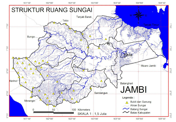
Struktur Sungai


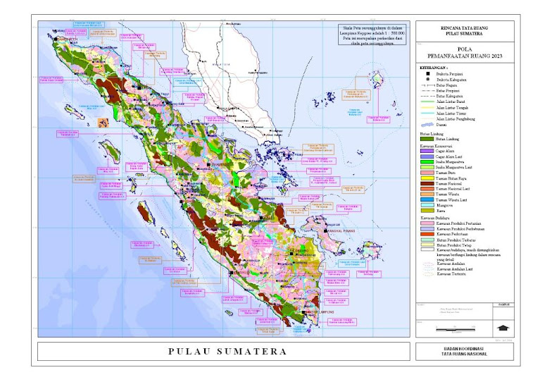
POLA RUANG SUMATERA
Kec. Jambi Selatan - Kota Jambi
BERHALE ISLAND

ISI IDRISI TAIGA

HOW TO GOIN ON BERHALE ISLAND

Langganan


 Postingan
Semua Komentar
Postingan
Semua Komentar
Kota Jambi

Desa Batu Kerbau - Kab. Bungo
TERAKHIR DI UPDATE GOOGLE


