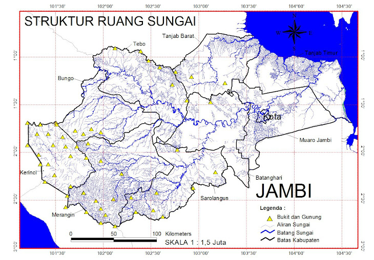
 cloud tops from northeast to southwest around the center of TD4W.") > View larger image
> View larger imageNASA's Aqua satellite's AIRS instrument infrared image on July 18 at 0723 UTC saw an area of very high thunderstorm (purple) cloud tops from northeast to southwest around the center of TD4W.
Credit: NASA/JPL, Ed Olsen NASA Infrared Image Sees Tropical Depression 4 Form in South China Sea
Tropical Depression 04W formed out of disturbance 98W this weekend after this passed over Luzon, the Philippines. NASA's Aqua satellite captured an infrared image that showed strong convection and thunderstorms in its center, helping confirm its organization into a tropical depression.
The Atmospheric Infrared Sounder (AIRS) instrument uses infrared capabilities to take the temperature of various factors associated with a tropical cyclone, from cloud top temperatures which indicate strength of thunderstorms within (colder cloud tops indicate higher, stronger thunderstorms) to sea surface temperatures (those greater than 80 Fahrenheit help power tropical cyclones). When NASA's Aqua satellite flew over Tropical Depression 04W (TD4W) on July 18 at 0723 UTC (3:23 a.m. EDT), it saw an area of very high thunderstorm cloud tops from northeast to southwest around the center of TD4W. Those temperatures were colder than -63 Fahrenheit and indicate strong convection (rapidly rising air that forms thunderstorms).
At 1500 UTC (11 a.m. EDT) on July 19 TD4W had still not consolidated and strengthened into a tropical storm. However, the sea surface temperatures in the South China Sea are warm enough to enable strengthening, as long as the wind shear remains low (which is it expected to do). TD4W had maximum sustained winds near 34 mph (30 knots) and higher gusts. It was located about 285 nautical miles west-northwest of Manila, the Philippines, near 15.9 North and 115.9 East. It was moving west-northwestward near 11 mph (10 knots).
TD4W is expected to strengthen into a tropical storm and move toward the northwest for a landfall south of Hong Kong in a couple of days.
Text credit: Rob Gutro, NASA/Goddard Space Flight Center


Tidak ada komentar:
Posting Komentar