Minggu, 18 Juli 2010

Climate Change Reality : Skeptics Versus Empirical Earth Science


The vast majority of good scientists today are comfortable with the current understanding of climate change, while recognizing that many complex components need continuous monitoring and measurements. At the same time, most scientists appreciate that basic knowledge of the physics of Earth’s systems needs further refinement and that the biological components and feedback mechanisms of Earth’s systems, though not fully known, play a significant role in climate change interactions and trends.

So what is the problem if a few scientists are not satisfied with knowledge of climate change science and do not agree with the consensus of the IPCC (www.ipcc.ch)? Fundamentally there is no problem. In fact, we should always cherish critical questioning of any hypotheses, data collection methods, or analyses of results. Unfortunately, a problem does arise when the empirical science of climate change has been whitewashed out of the public arena by climate change skeptic campaigns, many of which are financed by recalcitrant industries resisting environmental protection and Earth stewardship responsibilities.

Recent polling indicates that only about a third of our fellow citizens believe in climate change and in the links between fossil fuel, land use and the global climate phenomenon (www.pollingreport.com/enviro.htm). This proportion represents a precipitous drop in climate change awareness from just a few years ago. Such an appalling drop in citizen awareness of the scientific facts is disheartening to those of us who wish to focus our energy on issues of adaptation, mitigation, and societal transformation to obtain clean and renewable energy sources. The science of climate change is overwhelming. And that may be the problem. When people are overwhelmed, well, they simply cannot absorb the information. They turn off. This gap in citizen knowledge is being filled in with shock radio and biased television news programs that revel in their contrarian and conspiratorial disinformation campaigns.

Fortunately, climate change science curricula have received a lot of attention and funding by federal agencies over the past few years (e.g., NASA, NOAA, NSF, and others) to build academic understanding and to promote resources for universities and K-12 schools. This summer, the American Meteorological Society, in partnership with NASA, is launching Climate Studies: Introduction to Climate Science (1st Ed 2010 AMS). A significant library of student and investigator guides now exists with excellent and accessible writings on climate change, ranging from Tim Flanner’s The Weather Makers, to Jim Hansen’s Storms of My Grandchildren. Science and citizen awareness can and should be promulgated in every school to focus on explaining the hard facts regarding shifts in the Earth’s climate system, using visual Earth observation and field data.

A refreshing addition to the understanding of climate change and exposure to the science of shifting climate is evident in the work of Clark Labs, home of Idrisi remote sensing/GIS software. Clark Labs, directed by professor Ron Eastman, the 2010 winner of the Distinguished Career Award by the American Association of Geographers, is dedicated to getting climate change tools into the hands of citizens. Under Eastman’s leadership, Idrisi has been used in over 180 countries, making image processing and modeling accessible to thousands of government and university researchers across the world. Two new Idrisi applications, the Land Change Modeler and the Earth Trends Modeler, are particularly helpful in documenting climate change trends (www.clarklabs.org/products/Earth-Trends-Modeler.cfm). Pedagogic use of these, or similar remote sensing tools, might represent a new approach to demonstrating the facts of climate change.

To begin with, an empirical approach to climate change, the facts collected over the past century, must be placed before the student. The student should be encouraged to question and challenge each presented fact. Hard evidence should never avoid serious enquiry. From the time of Svante Arrhenius to Charles David Keeling, a litany of empirical facts has been largely ignored or unknown to the public (and sadly to many scientists too). The Keeling Curve is one of the most visually compelling datasets of our time and should be central to the dialogue for bringing together the climate change science puzzle (Figure 1). This curve can serve as the basis for a single lecture or a semester-long course, such is its power for science comprehension and research.
Two new Idrisi applications, the Land Change Modeler and the Earth Trends Modeler, are particularly helpful in documenting climate change trends. Pedagogic use of these, or similar remote sensing tools, might represent a new approach to demonstrating the facts of climate change.
The overarching question that needs to be asked of this curve: If CO2 continues to fill our atmosphere as it is doing now, what will be the outcome? (The second question – What can we do about it? – is the more difficult to address due to political, economic, and societal challenges. Consider the December 2009 Copenhagen U.N. Climate Summit.) Regarding the first question, we can utilize the Idrisi tools to document empirical data from Earth observation satellites and can empower students and professors with direct, first-hand interaction with climate change science data. This kind of interaction creates a remarkable transformation in observer attitudes.


When we examine sea surface temperatures over the period 1982 to 2006 using the Earth Trends Modeler (an unfortunate name, as it effectively documents empirical data versus “models”) we can readily see that a warming trend is evident, notably in the northern hemisphere (Figure 2). Image time-series data are requisite to document global climate change and for exploring such global events as El Niño and related sea surface temperature anomalies and impacts.

The major challenge, however, is in isolating true change from measurement artifacts and normal environmental variability. A variety of techniques, including a coordinated suite of data mining tools for time series analysis, is needed to effectively document sea-surface and land-surface changes associated with climate change. These tools can be applied to demonstrating the seasons’ shifts, such as the earlier onset of spring for regions such as Europe (Figure 3).

As students become more familiar with the empirical science and climate trends over the past couple of decades, they become better ambassadors for public awareness. We need a lot more ambassadors in this world if we hope to change the current polling trends and possibly convert media-bred skeptics into knowledgeable citizens. This conversion will require the widespread adoption of tools like Idrisi to upgrade our current school curricula and create a cadre of educated climate change ambassadors.

Sumber : http://www.imagingnotes.com/go/article_freeJ.php?mp_id=222#1

Menuntut Pengembalian Fungsi Taman


Warga Gamelan Protes


Masyarakat sekitar Jln. Gamelan-Rengkong yang tergabung dalam Masyarakat Peduli Lingkungan (MPL) Turangga memprotes penjualan dan pembangunan lahan taman di sekitar perumahan mereka. Mereka meminta lahan taman yang sudah dibabat pohon-pohonnya dikembalikan menjadi taman, sebagaimana tercetak dalam Rencana Detail Tata Ruang (RDTR) Kota Bandung.

"Tak hanya itu, di bawah taman ada septictank komunal dari 200 rumah yang ada di sekitar perumahan tersebut. Septictank itu dibuat sejak perumahan itu dibuat pada tahun 1970-an," kata Wakil Sekretaris MPL Turangga, John Simalango kepada "GM" di Redaksi "GM", Jln. Blk. Factoru, Kamis (15/7).

Dijelaskannya, pihaknya berharap Pemkot Bandung menghentikan pembangunan dan mengembalikan fungsi taman dan fasilitas umum serta septictank bagi ratusan rumah di sekitarnya.

"Kami juga meminta diusut tuntas adanya dugaan KKN dan menindak tegas setiap oknum yang terlibat dalam peralihan hak lahan taman yang jelas milik negara menjadi hak milik pribadi," ujarnya.

John mengungkapkan, lahan taman hijau di sekitar perumahan seluas 1.200 m2 itu, kini kepemilikannya sudah berada di tangan seseorang. Padahal duluahan tanah itu milik pemerintah.

"Kalau ada peralihan, tentu ada prosesnya. Harus ada persetujuan DPRD. Sejauh ini tidak ada peralihan hak lahan itu dengan persetujuan DPRD," kata John didampingi pengurus MPL lainnya.

Dikatakan John, apabila ada pihak yang meragukan adanya septictank komunal, sejumlah warga siap kamar mandinya atau sebagian rumahnya dibongkar. Setiap rumah di perumahan itu tidak memiliki septictank karena semua masuk ke satu saluran yang berunjung di bawah taman.

"Adanya septictank ini dibuktikan dengan testimoni R. Saleh, yang ikut merencanakan dan mengawasi pembangunan septictank pada 1972," katanya. (B.83)**


Share

Sumber :  http://www.klik-galamedia.com/indexnews.php?wartakode=20100717093257&idkolom=tatarbandung

Kasus Gagak Hitam dipersoalkan


   MEDAN - Pembangunan di kawasan Gagak Hitam kembali dipertanyakanlegislator Medan. Pasalnya, kawasan Gagak Hitam bukan merupakan kawasan bisnis.

“Sakit hati kita demi melihat ketidaksinkronan tata ruang di Kota Medan. Kawasan Gagak Hitam yang bukan merupakan kawasan bisnis, tetapi dibangun banyak ruko-ruko,” lontar anggota komisi D DPRD Medan, Budiman Panjaitan, sore ini kepada Waspada Online.

Selain itu, menurut Budiman, pembangunan Gagak Hitam ditenggarai banyak melanggar roilen. Termasuk juga pelanggaran ijin unit pembangunan. Bahkan ditegaskannya sama sekali ijinnya tidak ada.

“Apakah keadaan yang sekarang ini akan melegalkan kawasan tersebut menjadi kawasan bisnis,” urainya.

Karenanya, lanjut Budiman, menyikapi persoalan Gagak Hitam tersebut, dinas terkait yakni Dinas TRTB harus bertindak tegas untuk menertibkannya. Hal ini dilakukan demi penataan Kota Medan kedepan. “Karena kawasan tersebut untuk pemukiman penduduk,” tandasnya.

Menanggapi hal itu , Kabid Pengendalian dan Pemanfaatan Tata Ruang Tata Bangunan Kota Medan Ahmad Basyaruddin mengatakan, sebagian besar sekarang ini menurutnya sudah memiliki izin. Soal pelanggaran roilen dan unit, dikatakan Basyaruddin, pihaknya akan turun kembali ke lapangan guna melihat kondisi bangunan-bangunan yang ada di Gagak Hitam.

“Kita akan tinjau kembali bangunan di sana terkait pelanggaran izin yang diberikan,” ucapnya. Seperti diketahui, bangunan-bangunan di kawasan Gagak Hitam yang disebut-sebut milik salah seorang pengusaha (DLS), diduga perubahan peruntukkannya belum ada izinnya.
Editor: SASTROY BANGUN
(dat07/wol-mdn)

sumber : http://www.waspada.co.id/index.php?option=com_content&view=article&id=130515:kasus-gagak-hitam-dipersoalkan&catid=14:medan&Itemid=27

Software GIS Gratis

GRASS GIS (Geographic Resources Analysis Support System) is an open source, free software (FOSS) Geographical Information System (GIS) with raster, topological vector


Software GIS gratis
ENVI, the premier software solution for processing & analyzing geospatial imagery. Used by GIS & image analysts, scientists and researchers.
http://www.bing.com:80/search?q=software+gis+gratis

ENVI Software - Image Processing & Analysis Solutions
Definition: A Geographic Information System (GIS) is a collection of computer hardware, software and geographic data used to ArcReader & MapExplorer) - MapMaker Gratis - Brava
http://www.ittvis.com/ProductServices/ENVI.aspx

Geographic Information Systems Explained
Free Software Home / Register for your own page! Free GIS mapping Futuris Imager Harm's Tile (seamless) Orea Gratis Factuur
http://www.bestpricecomputers.co.uk/glossary/geographic-information-system.htm

myHq : Free Software
dengan menggunakan data Digital Elevation Model (DEM) SRTM dan software ArcGIS. Data DEM dengan resolusi 30 m (1 arc) saat ini sudah bisa didownload secara gratis. Software GIS
http://www.myhq.com/public/f/r/freesoft/

Delineasi Batas Daerah Aliran Sungai (DAS) « Regan Leonardus's Blog
It is available as the free program "Map Maker Gratis DIVA-GIS is free geographic information system (GIS) software.
http://reganleonardus.wordpress.com/2010/03/24/delineasi-batas-daerah-aliran-sungai-das/

Open source GIS
Variedad de Software CAD, versiones de Prueba y Full. 327 Visualizadores GIS para bajar! 1377 Recursos Gratis para GIS (EEUU)*
http://ppgis.iapad.org/opensource_gis.htm

Grupo SIG - FAM | Sistemas de Informacion Geografica | GIS - Enlaces ...
Download for free a terrific tutorial series on GIS called “introducing GIS” by GIS Books; GIS Data; GIS Software; GIS Tutorials; Satellite Image Wallpaper
http://www.sigfam.com.ar/component/option,com_weblinks/catid,25/Itemid,22/

Quantum GIS Tutorial | Free GIS Data Free GIS Tutorials
however, you might want to buy commercial Geographic Information System (GIS) software. with a well-defined set of photos and vector data, Gratis is
http://gisiana.info/free-gis-tutorial/quantum-gis-tutorial/

RTI: GIS Software Overview
 GIS Books; GIS Data; GIS Software; GIS Tutorials; Satellite Image Wallpaper
http://www.ruraltech.org/gis/map_info/gis_overview/index.asp

Free GIS Data - Makasar Map Scale 1:5,000 | Free GIS Data Free GIS ...
Please note that data available from this site requires users to be proficient in GIS and may require access to GIS software. Numerous data holdings are available for free download
http://gisiana.info/gis-data-vektor/free-gis-data-makasar-map-scale-15000/
http://data.geocomm.com/

Sumber informasi Serba Gratis:

Sumber : http://www.linkgratisan.co.cc/software-gis-gratis.php
Sponsor :


Alfin SH dan Azhar Hamzah: Memajukan Desa di Sungai Penuh melalui Implementasi Pedoman Pembangunan Desa dan SDGs

Sungai Penuh - Alfin SH dan Azhar Hamzah, calon walikota dan wakil walikota Sungai Penuh, berkomitmen memajukan desa-desa di wilayahnya deng...

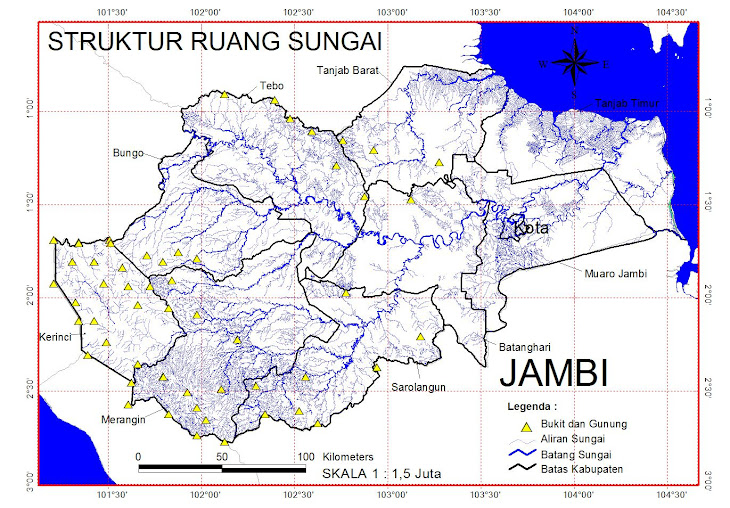
Struktur Sungai

Struktur Sungai

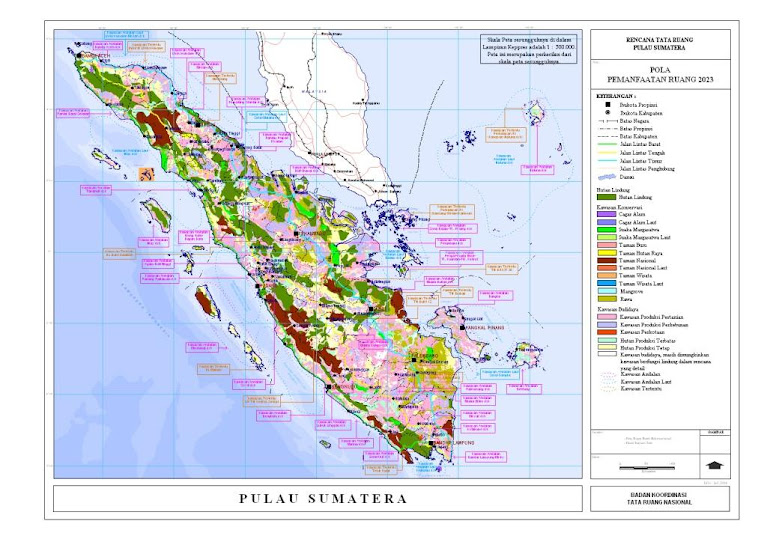
POLA RUANG SUMATERA

POLA RUANG SUMATERA

Kec. Jambi Selatan - Kota Jambi

Kec. Jambi Selatan - Kota Jambi

BERHALE ISLAND

Pulau Berhala
Large selection of World Maps at stepmap.com
StepMap Pulau Berhala


ISI IDRISI TAIGA

ISI IDRISI TAIGA

HOW TO GOIN ON BERHALE ISLAND

Kota Jambi

Desa Batu Kerbau - Kab. Bungo

Desa Batu Kerbau - Kab. Bungo

TERAKHIR DI UPDATE GOOGLE

COMMUNICATE

+62 812731537 01